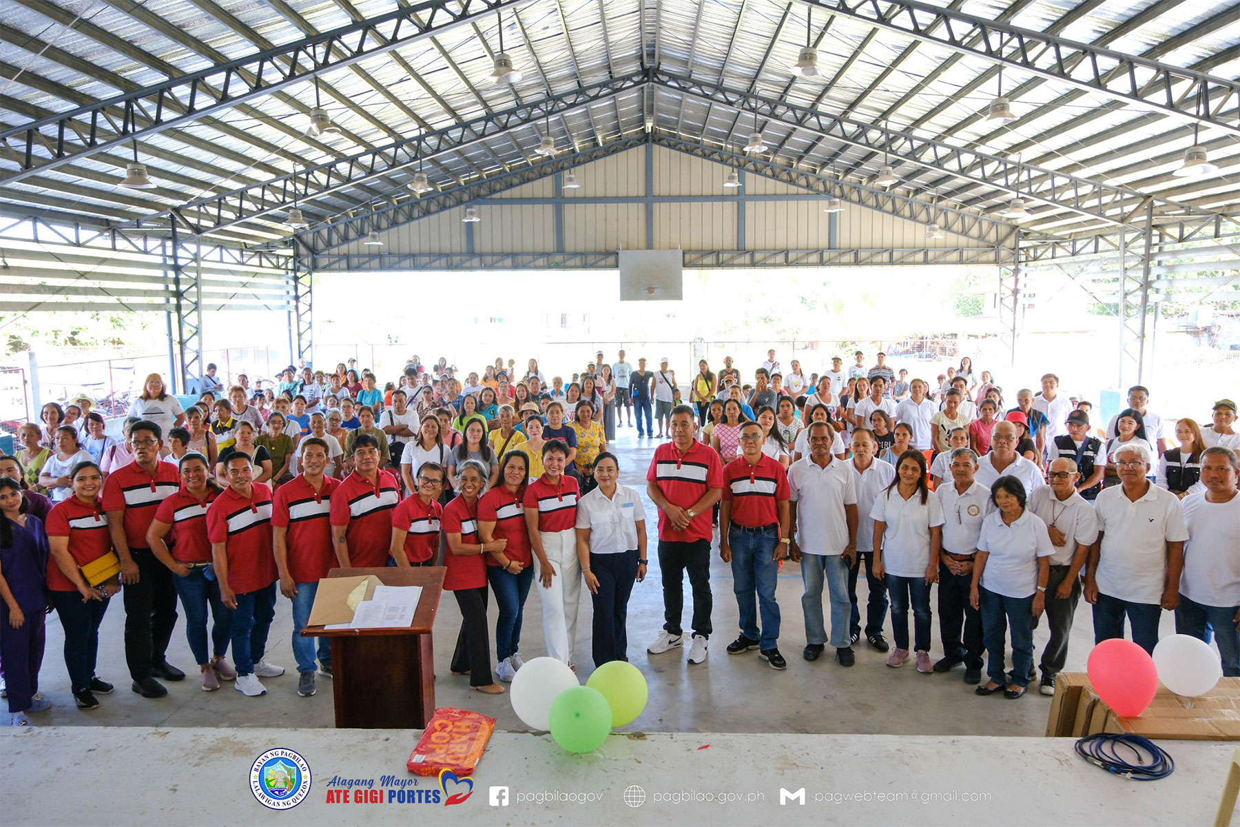
Pagbilao,
Quezon is one of the gateways to the South. The Municipality is located eight
(8) kilometers from Lucena City, the Provincial Capital of Quezon. Its
geographical coordinates are 14?0’0”N latitude and 121?45’0”E latitude. It is
bounded on the northeast by the City of Tayabas, northwest by Atimonan,
southeast by Padre Burgos and southwest by the City of Lucena. Pagbilao has a
total land area of 17,760 hectares as per Bureau of Lands Records. It is
composed of twenty seven (27) barangays; twenty one (21) of which are rural
barangays and six (6) are urban barangays.
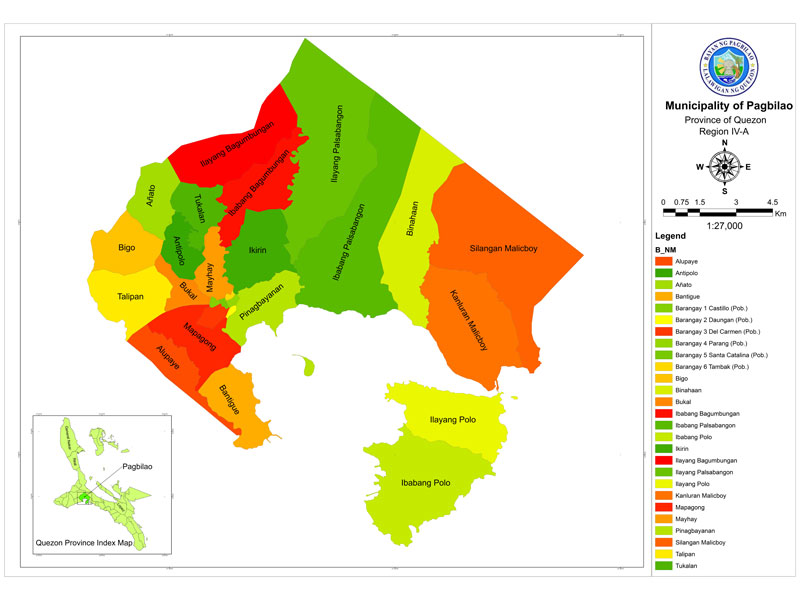
Topography
Pagbilao
is located generally on a hill side with a slope of 0-3%. The poblacion is
surrounded by agricultural crops like coconuts and rice while a small
percentage that of within the boundary of Mauban, has <30% slope.
The
highest elevation is found in the area of Silangang Malicboy and the lowest is
Barangay Bantigue. The area is within the range of Sierra Madre Mountain with nine
(9) barangays along the Pagbilao Bay area and five (5) barangays along the
Tambak River.
It
can be noted that there is seemingly four clusters which can best identify the
area-the poblacion barangays, the barangays along the Pagbilao Bay area, barangays
along the Maharlika Highway, and the forested barangays.
| 0 - 3% | Bantigue, Alupaye, Mapagong, Del Carmen, portion of Iba. Palsabangon,Binhaan | 520 has |
| 3 - 9% | portion of Pinagbaynan, Sil. Malicboy, Binhaan, Iba. Palsabangon, Kan. Malicboy | 10,400 has |
| 9 - 18% | Daungan, Parang, Talipan, Alupaye, Mapagong, Castillo, Portion of Pinagbayanan, Bukal, Bigo, Antipolo, Tucalan, Mayhay, Ikirin, Iba. Bagumbungan, Anato | 3,650 has |
| 18 – 30% | Ila. Bagumbungan, Iba. Polo, Ila. Polo, portion of Kan. Malicboy, portion of Ila. Bagumbungan, portion of Anato, Ila, Bagumbungan, Binhaan | 150 has |
| < 30% | Iba. Palabngon , portion of Sil. Malicboy, Binhaan, Iba. Palsabangon, Ila. Palsabangon | 1,100 has |
Pagbilao, Quezon Slope Map
Mountain Ranges
There are mountainous portions in the
municipality that are situated at Barangays Binahaan, Silangang Malicboy,
Kanlurang Malicboy, part of Ilayang Palsabangon and Ilayang Bagumbungan and in
the island barangays of Ilaya and Ibabang Polo.
Hydrogeologic Features
Generally, there is no fault line within the
area of Pagbilao. There is bountiful source of ground water due to forest areas
in the municipality aside from major rivers like the Palsabangon, Tambak,
Locohin, and the Binahaan rivers.
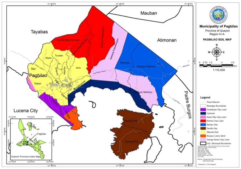
Soil
Per records of the Bureau of
Soils, Pagbilao has nine (9) types of soil, namely: Hydrosol, Guadalupe Clay
Loam, Bolinao Clay Loam, Macolod Clay Loam, Bantay Clay, Buguey Loamy Sand,
Ibaan Silty Clay Loam, Bruingan Sandy Clay Loam, and Sevilla Clay.
Soil Types and Location
| Barangays | Soil Type |
|---|---|
| Alupaye | Guadalupe Clay Loan & Buquey Loam |
| Antipolo | Macolod Clay Loam |
| Añato | Macolod Clay Loam |
| Bantigue | Buquey Loamy Sand |
| Iba. Bagumbungan | Macolod Clay Loam & Bolinao Clay Loam |
| Ila. Bagumbungan | Bolinao Clay Loam |
| Bigo | Macolod Clay Loam & Ibaan Silty Clay Loam |
| Binahaan | Bantay Clay & Quinga Sandy Clay Loam |
| Bukal | Macolod Clay Loam |
| Ikirin | Macolod Caly Loam |
| Mapagong | Macolod Clay Loam & Hydrosol |
| Kan. Malicboy | Quinga Sandy Clay Loam & Hydrosol |
| Sil. Malicboy | Bantay Clay |
| Mayhay | Macolod Caly Loam |
| Iba. Palsabangon | Quinga Candy Loamy & Hydrosol |
| Ila. Palsabangon | Bolinao Clay Loam |
| Pinagbayanan | Macolod Clay Loam & Hydrosol |
| Ibabang Polo | Sevilla Clay |
| Ilayang Polo | Sevilla Clay |
| Talipan | Guadalupe Clay Loam & Macolod Clay Loam |
| Tukalan | Macolod Clay Loam |
Source: Bureau of Soils, 1994
Soil Types, Area in Hectares
| Soil Type | Area in Hectares |
|---|---|
| Bolinao Clay Loam | 4,000 |
| Macolod Clay Loam | 3,600 |
| Bantay Clay | 2,800 |
| Hydrosol | 1,200 |
| Quinga Sandy Clay Loam | 1,600 |
| Guadalupe Clay Loam | 1,000 |
| Sevilla Clay | 1,120 |
| Buquey Loamy Sand | 350 |
| Ibaan Silty Clay Loam | 150 |
| Total | 15,820 |
Source: Bureau of Soils, 1994
Pagbilao, Quezon Soil Map
Mineral Resources
Limestone and industrial
lime reserves are estimated at 256,438.000 M.T. and which can be found in
Barangays Ilayang Bagumbungan, Silangan Malicboy, Kanlurang Malicboy and
Ilayang Polo. It has an aggregate area of 27.0514 hectares.
Only a portion of Ilayang Bagumbungan is permitted for exploration for limestone manufacturing, eventually opening job opportunities for the unemployed sector of the population and the development of the surrounding area.
Water Resources
The
main source of potable water of the people is the Quezon Metropolitan Water
District (QMWD) with water schedule on rotation from 10 am to 10 pm. Other
sources are the three major rivers, rain water, open well, natural springs
scattered around the area, piped water and other watershed area in the
municipality.
Forest Resources
The municipality has a
total of 1,433.9350 hectares of forest area located at Barangays Malicboy,
Binahaan, Ilayang Palsabangon, Ilayang Bagumbungan, Ilaya and Ibabang Polo.
The forest area within Silangang Malicboy is part of the Quezon National Forest Park classified as a virgin dipterocarp forest. A portion of the forest area within barangays Binahaan and Ilayang Palsabangon had been subjected to timber licensing agreement but has been suspended since 1978. However it has been observed that some portions are being utilized by Kaingeros.
Climate
The municipality of
Pagbilao used to have two (2) types of climate – dry and wet seasons (source
Socio Economic Profile of Pagbilao, Quezon 1984) with a very pronounced maximum
rainfall from November to January. This is due to its nearness to the eastern coast
and is not sheltered from the northeast monsoon, trade winds and storm.
This, however, had been
refuted repeatedly as rains and dry periods have no prominent season anymore.
Because during summer which should have been hot is raining much and at times
with storms and the other way around during rainy season. In other words, still
there are two seasons. And yet one will just guess when will it be prominent.
This is primarily predicated to the climate change which brings the conditions
to extreme - both raining or shine.